Happening Now

Updates to Ian’s Impact on Alabama Including Fire Advisory

Ian Update

Calhoun County, AL – Per the Alabama Emergency Management Agency Ian is forecast to make landfall this afternoon near Port Charlotte (southeast of Tampa) as a Category 4 hurricane with sustained winds of 140 mph.  This will cause devastating impacts from wind, high storm surge, flooding rains, and tornadoes due to very slow movement through the FL Peninsula today through Thursday.

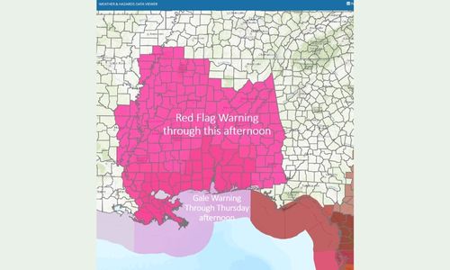
Concerning Alabama: A Gale Warning is in effect for the AL coastal waters through 6 pm Thursday with northerly winds of 25-35 mph and gusts to 45 mph.

A Red Flag Warning is in effect for most of the state through this afternoon with northerly winds from 10-20 mph and with gusts up to 30 mph.  This will likely be extended into at least Thursday.  The combination of gusty winds and low relative humidity will result in increased fire danger.  Do not do any outdoor burning. The Anniston Fire Department shared that there is a wildfire advisory for most of Alabama with Hurricane Ian soon to make landfall in Florida, the state of Alabama will be situated on the dry side of the storm. On Wednesday, Alabama will be seeing lower than normal relative humidity and stronger winds across the state, meaning conditions are favorable for wildfires to start easily, spread rapidly, and be difficult to control. Because Alabama is already experiencing dry conditions heading into the event, this critical weather behavior will elevate fire danger for the state.

The Alabama Forestry Commission is urging caution on any outdoor burning. If you must burn, or have burned in the last few days, please check your fires to make sure they are properly extinguished. Smoking piles immediately adjacent to flammable vegetation have the chance to rekindle and spread under these conditions.
Weather predictions for Alabama on Wednesday include relative humidity under 25 percent and sustained winds close to 15 mph with stronger gusts in areas. Red Flag Warnings have already been issued by the National Weather Service (NWS) for Baldwin, Butler, Clarke, Choctaw, Conecuh, Covington, Crenshaw, Escambia, Mobile, Monroe, Washington, and Wilcox counties. A Fire Weather Watch is also being issued by the NWS for Wednesday, September 28, for the following counties: Autauga, Barbour, Bibb, Blount, Bullock, Calhoun, Chambers, Cherokee, Chilton, Clay, Cleburne, Coosa, Dallas, Elmore, Etowah, Fayette, Greene, Hale, Jefferson, Lamar, Lee, Lowndes, Macon, Marengo, Marion, Montgomery, Perry, Pickens, Pike, Randolph, Russell, Shelby, St. Clair, Sumter, Talladega, Tallapoosa, Tuscaloosa, and Walker. Please pay attention to local weather outlets as fire weather conditions may change through the weekend.
The mission of the Alabama Forestry Commission is to protect and sustain Alabama’s forest resources using professionally applied stewardship principles and education, ensuring that the state’s forests contribute to abundant timber and wildlife, clean air and water, and a healthy economy.

A very tight rainfall gradient will occur with Ian and total rainfall Friday through Saturday will range from around 1 inch along the AL/GA state line to nothing from I-65 and areas westward.

Paid Advertisement – Click for More Information

Debbie Hess for BOE
RMC Foundation

Paid Advertisement – Click for More Information

JLM Coms
Julie Borrelli for Probate

Paid Advertisement – Click for More Information

McClellan Inn Ad

Paid Advertisement – Click for More Information

A Better Body Chiropractic